


FlyQ Pocket
Описание FlyQ Pocket
FlyQ Pocket from Seattle Avionics is the absolutely free, powerful aviation app that every pilot needs. It’s brilliantly easy to use and astonishingly fast. It takes full advantage of the Internet when available but also stores information on the device for offline use.
FlyQ Pocket combines aviation weather, airport info, FBO info, fuel prices, and flight planning capability to put tremendous power just a click or two away. You can plan a flight with an auto-router that wind-optimizes your flight to get you there as fast as possible. Victor Airways, GPS Direct routing, Jet Airways, or None. FlyQ Pocket is ready for it all.
FlyQ Pocket shares flight plans, pilot profiles, and aircraft profiles with FlyQ EFB for iPad and FlyQ Online for Web.
Using FlyQ Pocket is simple because all major functions are always just a tap away.
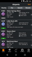
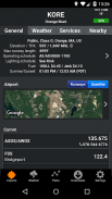
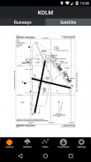
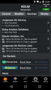
Airport Information
Start FlyQ Pocket and within seconds it finds the nearest airports and displays succinct weather, fuel, and operational details about them—without even tapping a button. Or use the Search feature to find airports by ident or name. Even browse by state/city to select airports without typing. Want more info about an airport? Tap and all the details you need (but no excess clutter) appears instantly. On the first airport page, you immediately see operational information, fuel prices, runways, navaids, the FAA airport diagram (if applicable) and an embedded satellite map image of the airport. Want to call the local ATIS? Tap the phone number and your SmartPhone quickly connects you. Tap the weather tab and see the current temperature and sky conditions, a Nexrad radar image of the area, the nearest METARs and TAFs, winds-aloft, and even an official Lockheed Martin or DUATS weather briefing. Best of all for those of us who aren’t 21 anymore, one tap zooms the METARs, TAFs and weather graphics to full screen, large font versions that anyone can read—even in turbulence. Another tap gives you an easy-to-read 7 day forecast. Quickly find the FBO details you need—fuel information, telephone numbers, rental cars, nearby attractions and more. The Favorites feature gives quick access to commonly-used airports.
Weather Information
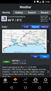
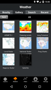
Tap the Weather tab and FlyQ Pocket instantly locks on to your GPS position and displays temperature, Nexrad images and local METARs and TAFs. Or choose from a large gallery of US and Canadian weather graphics, many of which are animated. Quickly check the weather anywhere on the globe by entering an airport identifier, city name, even a zip code. Of course, FlyQ Pocket keeps track of your recent selections for quick future access and stores graphics and METARs/TAFs on the phone so they’re available even when you’re not connected to the Internet (such as in flight).
Flight Planning
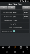
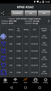
No time to plan a flight? Give us 30 seconds and watch FlyQ Pocket assemble the perfect wind-optimized flight plan. Tell FlyQ Pocket where to depart, where to land, and how to fly there (Victor airways, Jet Airways or GPS Direct) and FlyQ Pocket plots the whole course including all the navaids and intersection—not a simple straight line. It even uses the winds-aloft forecast to give you the ideal altitude for each leg of your trip. To make your life easier, FlyQ Pocket automatically requests an official Lockheed Martin or DUATS weather briefing so you’re good to go. And since filing the flight plan takes one tap and about 3 seconds, it’s easy and quick to fly safely. FlyQ Pocket remembers your recent flights and home airport so you can often plan a flight by picking from a list of recently used airports rather than typing.
Moving Map and Approach Plates
FlyQ Pocket does not include a moving map or approach plates. It’s designed for pre-flight planning rather than in-flight use. FlyQ EFB for iPad is the big brother to FlyQ Pocket with step up features like a Moving Map. See FlyQ Online for a Web-based flight planning solution.
FlyQ Карманный из Сиэтла Avionics это абсолютно бесплатно, мощная авиация приложение, которое каждый пилот должен. Это блестяще простой в использовании и удивительно быстро. Это в полной мере использовать преимущества Интернета, когда доступный, но и хранит информацию на устройстве для использования в автономном режиме.
FlyQ Карманный сочетает авиации погода, данные аэропорта, FBO информация, цены на топливо, а также возможность планирования полетов поставить огромную власть как раз щелчок или два прочь. Вы можете планировать полет с авто-маршрутизатор, который ветром оптимизирует свой рейс, чтобы вы там как можно быстрее. Victor Airways, GPS Прямая маршрутизация, Jet Airways или Нет. FlyQ Карманный готов для него все.
FlyQ Карманные планы акций полета, пилот-профили и авиационные профили с FlyQ EFB для IPad и FlyQ онлайн для Web.
Использование FlyQ Карман просто потому, что все основные функции всегда просто прикосновением.
информация об аэропорте
Запустите FlyQ карман и в течение нескольких секунд он находит ближайших аэропортов и отображает сжатое погода, топливо и эксплуатационные детали о них-даже без нажатия кнопки. Или используйте функцию поиска, чтобы найти аэропортов от идент или имени. Даже просматривать на государственном / города, чтобы выбрать аэропорты без ввода. Хотите больше информации о аэропорту? Нажмите и все детали, которые необходимо (но без избытка помех) не появляется мгновенно. На первой странице аэропорта, вы сразу видите оперативную информацию, цены на топливо, взлетно-посадочных полос, навигационного оборудования, схема аэропорта FAA (если это применимо) и встроенный спутник изображение карты аэропорта. Хотите позвонить в местный АТИС? Нажмите на номер телефона и смартфоном быстро соединяет вас. Выберите вкладку погоды и увидеть текущую температуру и состояние неба, радиолокационную NEXRAD изображение области, ближайший METARs и ветры вания TAF-парить в воздухе, и даже официальный Lockheed Martin или DUATS погоды брифинг. Лучше всего для тех из нас, кто не 21 больше, один кран, масштабирует METARs, и погодные вания TAF графики на весь экран, большие версии шрифта, что любой человек может читать даже в условиях турбулентности. Другой кран дает вам простой для чтения прогноз на 7 дней. Быстро найти детали FBO нужно топливовоздушной информацию, телефоны, аренда автомобилей, близлежащие достопримечательности и многое другое. В Избранные функции позволяет получить быстрый доступ к наиболее часто используемых аэропортов.
информация о погоде
Нажмите на вкладку Погода и FlyQ Карманный мгновенно запирает на вашей позиции GPS и температуры дисплеи, NEXRAD изображений и местные сводки METAR и прогнозы TAF. Или выбрать из большого галереи канадской погоды графики, многие из которых являются анимированными США и. Быстро проверить где-нибудь о погоде на земном шаре, введя идентификатор аэропорта, название города, даже почтовый индекс. Конечно, FlyQ Карманный отслеживает последние выборов для быстрого доступа в будущем и хранит графики и METARs / прогнозы TAF по телефону, так что они доступны, даже если вы не подключены к Интернету (например, в полете).
Планирование полетов
Нет времени, чтобы спланировать полет? Дайте нам 30 секунд и смотреть FlyQ Карманный собрать идеальный ветер оптимизированный план полета. Скажите FlyQ карман, где отойти, где на землю, и как лететь туда (Виктор Airways, Jet Airways или GPS-Direct) и FlyQ карманные участки весь курс, включая все навигационные знаки и пересечения-не простой прямой. Он даже использует ветры-Aloft прогноз, чтобы дать вам идеальную высоту для каждой ноги вашей поездки. Для того, чтобы сделать вашу жизнь проще, FlyQ Карманный автоматически запрашивает официальный Lockheed Martin или DUATS погоды брифинг, так что вы хорошо идти. А так подачи плана полета занимает один кран и около 3 секунд, это легко и быстро летать безопасно. FlyQ Карманный запоминает ваши последние полеты и домашний аэропорт, так что вы можете часто планировать полет на выбор из списка недавно использованных аэропортах, а не вводить.
Перемещение Карта и захода на посадку Плиты
FlyQ карманный не включает в себя перемещение карты или захода на посадку пластины. Он предназначен для предполетного планирования, а не использовать в полете. FlyQ EFB для IPad является большой брат FlyQ карман с шагом до функций, таких как Moving Map. См FlyQ Интернет для решения веб-планирования полетов.
FlyQ Pocket from Seattle Avionics is the absolutely free, powerful aviation app that every pilot needs. It’s brilliantly easy to use and astonishingly fast. It takes full advantage of the Internet when available but also stores information on the device for offline use.
FlyQ Pocket combines aviation weather, airport info, FBO info, fuel prices, and flight planning capability to put tremendous power just a click or two away. You can plan a flight with an auto-router that wind-optimizes your flight to get you there as fast as possible. Victor Airways, GPS Direct routing, Jet Airways, or None. FlyQ Pocket is ready for it all.
FlyQ Pocket shares flight plans, pilot profiles, and aircraft profiles with FlyQ EFB for iPad and FlyQ Online for Web.
Using FlyQ Pocket is simple because all major functions are always just a tap away.
Airport Information
Start FlyQ Pocket and within seconds it finds the nearest airports and displays succinct weather, fuel, and operational details about them—without even tapping a button. Or use the Search feature to find airports by ident or name. Even browse by state/city to select airports without typing. Want more info about an airport? Tap and all the details you need (but no excess clutter) appears instantly. On the first airport page, you immediately see operational information, fuel prices, runways, navaids, the FAA airport diagram (if applicable) and an embedded satellite map image of the airport. Want to call the local ATIS? Tap the phone number and your SmartPhone quickly connects you. Tap the weather tab and see the current temperature and sky conditions, a Nexrad radar image of the area, the nearest METARs and TAFs, winds-aloft, and even an official Lockheed Martin or DUATS weather briefing. Best of all for those of us who aren’t 21 anymore, one tap zooms the METARs, TAFs and weather graphics to full screen, large font versions that anyone can read—even in turbulence. Another tap gives you an easy-to-read 7 day forecast. Quickly find the FBO details you need—fuel information, telephone numbers, rental cars, nearby attractions and more. The Favorites feature gives quick access to commonly-used airports.
Weather Information
Tap the Weather tab and FlyQ Pocket instantly locks on to your GPS position and displays temperature, Nexrad images and local METARs and TAFs. Or choose from a large gallery of US and Canadian weather graphics, many of which are animated. Quickly check the weather anywhere on the globe by entering an airport identifier, city name, even a zip code. Of course, FlyQ Pocket keeps track of your recent selections for quick future access and stores graphics and METARs/TAFs on the phone so they’re available even when you’re not connected to the Internet (such as in flight).
Flight Planning
No time to plan a flight? Give us 30 seconds and watch FlyQ Pocket assemble the perfect wind-optimized flight plan. Tell FlyQ Pocket where to depart, where to land, and how to fly there (Victor airways, Jet Airways or GPS Direct) and FlyQ Pocket plots the whole course including all the navaids and intersection—not a simple straight line. It even uses the winds-aloft forecast to give you the ideal altitude for each leg of your trip. To make your life easier, FlyQ Pocket automatically requests an official Lockheed Martin or DUATS weather briefing so you’re good to go. And since filing the flight plan takes one tap and about 3 seconds, it’s easy and quick to fly safely. FlyQ Pocket remembers your recent flights and home airport so you can often plan a flight by picking from a list of recently used airports rather than typing.
Moving Map and Approach Plates
FlyQ Pocket does not include a moving map or approach plates. It’s designed for pre-flight planning rather than in-flight use. FlyQ EFB for iPad is the big brother to FlyQ Pocket with step up features like a Moving Map. See FlyQ Online for a Web-based flight planning solution.
FlyQ Pocket - Информация об APK
Версия APK: 2.2Пакет: org.seattleavionics.flyqПоследняя версия FlyQ Pocket


Приложения в этой категории

Вам также могут понравиться...


